E-ISSN:2583-0074

Research Article

Medical Facilities

Social Science Journal for Advanced Research

2025 Volume 5 Number 4 July
Publisherwww.singhpublication.com

A Statistical Analysis of Medical Facilities in Satara District: Geographical Study

Yadav SS1*, Wagh AS2, Nimbale SM3
DOI:10.5281/zenodo.16750405

1* Sushil S. Yadav, Research Scholar, Department of Geography, Shivaji University, Kolhapur, Maharashtra, India.

2 Arjun Shivaji Wagh, Assistant Professor, Padmabhushan Dr. Vasantraodada Patil Mahavidyalaya, Tasgaon, Sangali, Maharashtra, India.

3 Sharadkumar M. Nimbale, Assistant Professor, Yashavantrao Chavan Institute of Science, Satara, Maharashtra, India.

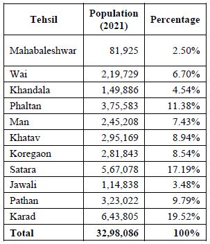
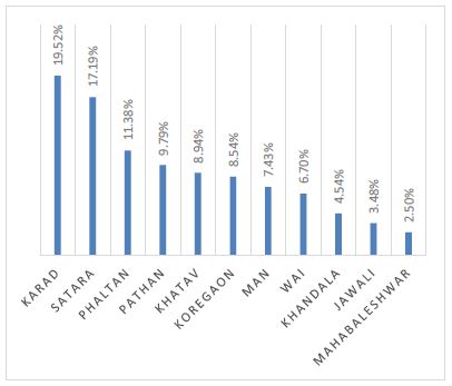
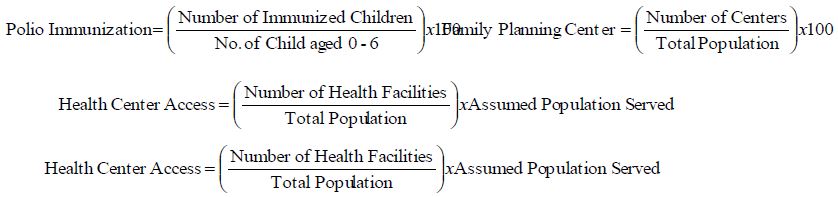
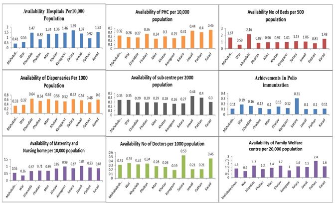
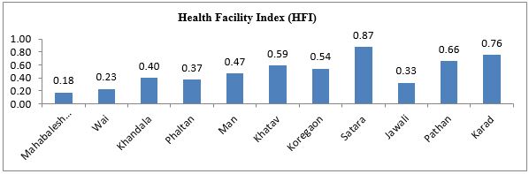
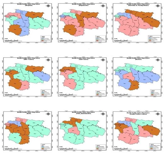
This study presents a comprehensive statistical analysis of medical facilities provided by Government in Satara district, aiming to provide insights into the healthcare infrastructure and accessibility in the geographical region. The Satara district is a located in the state of Maharashtra, India, encompasses diverse geographical and demographic characteristics, making it imperative to understand the distribution and adequacy of medical resources. Key Statistical Indicators such as the number of healthcare facilities per capita, bed capacity, availability of medical staff, and infrastructure are analyzed to assess the overall healthcare provision in Satara district. Moreover, the study evaluates the geographical distribution of medical facilities to identify potential gaps and disparities in healthcare access, particularly in rural and remote areas. The findings of this study contribute valuable insights for healthcare policymakers, practitioners, and stakeholders to formulate targeted interventions and policies aimed at enhancing the quality and accessibility of healthcare services in Satara district. By addressing the identified gaps and leveraging existing resources effectively, it is envisaged that the overall health outcomes and well-being of the population in Satara district can be significantly improved. It will be fide out the role of medical facilities in human development index.

Keywords: statistical analysis, health index, population, demographic characteristics, accessibility

Corresponding Author How to Cite this Article To Browse
Sushil S. Yadav, Research Scholar, Department of Geography, Shivaji University, Kolhapur, Maharashtra, India.
Email:
Yadav SS, Wagh AS, Nimbale SM, A Statistical Analysis of Medical Facilities in Satara District: Geographical Study. Soc Sci J Adv Res. 2025;5(4):90-97.
Available From
https://ssjar.singhpublication.com/index.php/ojs/article/view/271

Manuscript Received Review Round 1 Review Round 2 Review Round 3 Accepted
2025-06-14 2025-07-04 2025-07-23
Conflict of Interest Funding Ethical Approval Plagiarism X-checker Note
None Nil Yes 3.32

© 2025 by Yadav SS, Wagh AS, Nimbale SM and Published by Singh Publication. This is an Open Access article licensed under a Creative Commons Attribution 4.0 International License https://creativecommons.org/licenses/by/4.0/ unported [CC BY 4.0].

Download PDFBack To Article1. Introduction2. Study Area3. Objectives4. Research
Methodology
5. Regional
Analysis of
Healthcare
Infrastructures
6. ConclusionReferences

1. Introduction

Health is a fundamental human right and a cornerstone of human welfare. It is essential for human resource development and the creation of a healthy society that can contribute effectively to overall progress (Mahata & Sharma, 2017). The World Health Organization (WHO) define health as "a state of complete physical, mental, and social well-being, and not merely the absence of disease or infirmity." Good health is not only a means to an end but also an end in itself. However, evidence suggests that ill health disproportionately affects the poor, who often lack adequate insurance to protect themselves against health risks. This reinforces the link between poverty and poor health (Bhupender Sing, 2004). Economic development often leads to regional disparities in various aspects of human well-being, including health. No state or district can be considered entirely developed due to differences in physical, economic, social, and political conditions. These disparities are evident in the health sector, where the spatial distribution of healthcare facilities is often imbalanced. Regional disparities persist across various levels in India, including states, districts, and even tehsils. Analyzing regional disparities in healthcare facilities helps administrators, policymakers, and planners identify areas with varying levels of development. This knowledge is crucial for understanding the specific requirements of different regions and addressing regional imbalances to achieve balanced development across all dimensions and regions (Kumar, 2019). The Health Index is a crucial tool in modern India for assessing and improving healthcare outcomes, promoting accountability, and supporting policy formulation (Peters et al.,2008) It provides a comparative analysis of health indicators across states, helping identify gaps and drive equitable healthcare initiatives. By highlighting disparities, the index encourages focused interventions for underperforming regions and marginalized communities, reducing inequalities in access and quality. It supports economic growth by fostering a healthier and more productive workforce, aligning with India's demographic dividend. Additionally, it plays a vital role in pandemic preparedness by evaluating the resilience and readiness of healthcare systems (Levesque et al., 2013). The Health Index also boosts innovation and investment in healthcare infrastructure, drawing private and international collaboration.

With growing emphasis on digital health initiatives like the Ayushman Bharat Digital Mission, the index serves as a benchmark for integrating technology into healthcare delivery. Overall, the Health Index is indispensable in guiding India toward achieving universal health coverage and ensuring the well-being of its citizens (Pillay & Maharaj, 2013).

2. Study Area

Satara is a district in the Indian state of Maharashtra. It covers an area of 10,480 square kilometers, which constitutes 3.40% of Maharashtra's total land area. Geographically, it lies between 17°10'N and 18°11'N latitude and 73°33'E and 74°54'E longitude. The Sahyadri range, a part Satara district, nestled on the Western Ghats, extends north-south along its western border, separating it from Ratnagiri district. Situated on the western Deccan Plateau, it lies within the Krishna and Bhima river basins. Satara is bordered by Pune district to the north, Solapur district to the east, Sangli district to the south, Ratnagiri district to the west, and Raigad district to the north-west

ssjar_271_Map01.JPG
Map No 1:
Location Map of Satara District

3. Objectives

1. Create an index to quantify the disparities in healthcare facilities across different tehsils within the study area.
2. To classify tehsils within Satara district as developed, moderately developed, or underdeveloped based on their healthcare facilities, using the developed Health Facility Index.

4. Research Methodology

The Health Facility Index (HFI) is a proposed measure to evaluate the accessibility and capacity of healthcare services in a region.


Accessibility to a well-distributed network of facilities such as clinics, hospitals, maternity homes, and primary care centers is crucial for ensuring timely medical attention and effectively addressing health concerns (Roy, 2008). Geographically disadvantaged areas like Satara, with rugged terrain and dense forests, face challenges in maintaining physical accessibility to healthcare. The HFI helps assess whether the minimum required facilities, proportionate to population density, are available in such areas. It considers various healthcare institutions, including government hospitals, dispensaries, primary health centers (PHCs), sub-centers, and private clinics, recognizing their differing capacities to serve populations. For instance, hospitals, PHCs, and nursing homes may cater to 10,000 people each, while dispensaries and sub-centers serve smaller groups (Census of India, 2011). This structured approach ensures the adequacy of health services and identifies gaps, aiding in targeted interventions to enhance healthcare delivery.

Study Area and Population: The study focuses on the Satara district, Maharashtra, which had a population of 3,298,086 in 2021, distributed across 11 tehsils. Key population statistics, including density and literacy rate, were analyzed to understand healthcare demand.

Table 1: Population of Satara District 2021

ssjar_271_Table01.JPG

ssjar_271_Graph01.JPG

Health Facility Index: The Health Facility Index is computed for various health components such as Health Center Access, Doctor Availability, Beds Availability in Hospitals, Achievement in Polio Immunization and Availability of Family Planning Centers are computed as follow.

ssjar_271_Formaul01.JPG

Data Normalization: Data normalization scales values to a uniform range, ensuring comparability across tehsils regardless of size or resources. It eliminates scale bias, highlights relative performance, and allows fair evaluation. Normalization enables accurate weighting and aggregation in indices, ensuring balanced results. This process simplifies identifying strengths and gaps, aiding informed decisions and policy interventions.

The Steps to calculating the Normalized Value & Health Facility Index (HFI) are as follow:

Step-by-Step:

Step 1: Normalize the Data:-

ssjar_271_Formula02.JPG
Step 2:
Assign Weights

Weights can be assigned based on the importance of each indicator to the health system

ssjar_271_Formula03.JPG


Step 3: Multiply Normalized Values by Weights

Step 4: Sum the Weighted Normalized Values

Health Facility Index(HFI) = ∑ (Weighted Normalized Values)


Table 2: Population of Satara District 2021

Normalized
Values
Availability of
Health Centers
DispensariesMaternity &
Nursing Homes
PHC
Centers
Sub-
centers
DoctorsBedsPolio
Immunization
Family Welfare
Centers
HFI
Mahabaleshwar0.290.130.160.210.260.120.210.050.160.18
Wai0.330.310.190.290.430.140.130.120.190.23
Khandala0.880.580.300.290.340.280.510.140.300.40
Phaltan0.190.270.530.500.540.390.170.250.530.37
Man0.960.780.400.430.540.310.370.140.400.47
Khatav1.000.850.580.640.630.340.490.240.580.59
Koregaon0.940.760.650.500.550.230.440.200.650.54
Satara0.660.950.880.860.721.001.001.000.880.87
Jawali0.940.340.280.360.380.110.230.060.280.33
Pathan0.620.810.880.930.980.300.410.190.880.66
Karad0.441.001.001.001.000.560.480.411.000.76

5. Regional Analysis of Healthcare Infrastructures

The collective Health Facility Index resolute for the eleven Tahsils of Satara district presents a very diverse picture. Besides Satara and Karad Tahsils, all the other Tahsils show a Health Facility Index below 0.75.

This suggests that healthcare facilities in the Satara district are mainly concerted in Satara and Karad while the situation in the remaining Tahsils is unsatisfactory. Particularly, Wai, Man, Jawali, Khandala and Mahabaleshwar show a very poor state of the healthcare sector.


Table 3: Satara District Availability of Medical Facility & Health Facility Index

TehsilHospitalsDispensariesMaternity &
Nursing Homes
PHC
Centers
Sub-
centers
DoctorsBedsPolio
Immunization
Family Welfare
Centers
HFI
Mahabaleshwar0.410.330.550.320.350.311.670.111.30.18
Wai0.550.370.360.280.350.350.590.190.90.23
Khandala1.470.640.670.270.290.322.160.161.70.40
Phaltan0.820.540.710.360.290.340.880.121.20.37
Man1.340.620.690.240.290.280.960.101.40.47
Khatav1.360.560.850.300.280.260.970.151.70.59
Koregaon1.460.520.990.250.260.191.010.121.00.54
Satara1.690.620.870.310.270.531.130.311.60.87
Jawali1.370.571.040.440.440.211.060.101.50.33
Pathan0.920.480.930.400.400.210.810.102.40.66
Karad1.530.600.870.460.300.461.480.111.60.76

Availability of Hospitals

Considering the availability of hospitals per 10,000 population in Satara district, the average availability of hospitals is 1.90 and the highest availability in Satara, Karad, Khandala, tehsils and the lowest availability is in Wai, Mahabaleshwar, and Phaltan tehsils. In the Man, Khatav, Koregaon & Jawali Tesils are medium availability of hospital per 10000 populations.

Availability of Dispensaries

Considering the availability of Dispensaries per 1000 population in Satara district, the average availability of Dispensaries is 0.53 and the highest availability in Khandala, Satara, Man, Karad tehsils and the lowest availability in the Mahabaleshwar, Wai, Pathan tehsils. In the Khatav, Koregaon & Jawali Tesils are medium availability of Dispensaries per 1000 population.


ssjar_271_Graph02.JPG
Graph 2:
Satara District Availability of Medical Facility & Health Facility Index

Availability Maternity and Nursing Homes

Considering the availability Maternity and Nursing homesper 10,000 population in Satara district, the average availability Maternity and Nursing homesis 0.77 and the highest availability in Jawali, Korgaon, Pathan ,Satara and Karad tehsils and the lowest availability is in Wai, Mahabaleshwar, and Khandal tehsils. In the Man, Khatav, Koregaon & Jawali Tesils are medium availability of Maternity and Nursing homes per 10000 population.

Availability of PHC

Considering the availability of of PHC per 10,000 population in Satara district, the average availability of of PHC 10,000 population is 0.33 and the highest availability in Karad, Jawali and Pathan tehsils and the lowest availability in the Man, Khandala and Wai tehsils. In the Phaltan, Satara and Khatv Tesils are medium availability PHC per 10,000 populations in Satara district.

Availability of Sub Centers

Considering the availability of Sub centre per 2000 population in Satara district, the average availability of Sub centre per 2000 population is 0.32 and the highest availability in Jawali, Pathan, Wai and Mahabaleshwar tehsils and the lowest availability in the Koregaon, Satara, Khataw tehsils. In the Khandala, Phaltan and Man Tesils are medium availability of Sub centre per 2000 population.

Availability No of Doctors

Considering the availability No of Doctors per 1000 population in Satara district, the average availability of hospitals is 0.31 and the highest availability in Satara and Karad tehsils and the lowest availability of doctors in the Koregaon, Jawali and Pathan tehsils.

In the Mahabaleshwar, Wai and Phaltan Tesils are medium availability No of Doctors per 1000 population.

Availability No of Beds

Considering the availability No of Beds per500 population in Satara district, the average availability of Beds is 1.15 and the highest availability in Khandala, Mahabaleshwar and Karad tehsils and the lowest availability No of Beds in the Wai, Pathan and Phaltan tehsils. In the Koregaon, Jawali and Satara Tesils are medium availability No of Beds per 500 populatio.

Achievements in Polio Immunization

Regarding polio immunization in Satara district, this research has shown that polio vaccination is being effectively implemented in all tehsils in the 0 - 6 age group, however, being the district headquarters, Satara tehsil has recorded the highest number of polio immunization and average immunization rate of Satara district has 0.14, while the lowest immunization rates are in Jawali, Pathan, Man and Mahabaleshwar tehsil of Satara district.

Availability of Family Welfare

Considering the family Welfare centers in Satara district, 1.48 family Welfare centers per 20000 population are available in Satara district, the highest availability of family welfare centers is in Pathan, Khatav, Satara and Karad tehsil have more than average availability of family welfare centers while the lowest availability in the Koregaon and Phaltan tehsils of satara district.

Health Facility Index (HFI)

ssjar_271_Graph03.JPG
Graph 3:
Overall Health Facility Index (HFI)

1. Less Developed (< 0.50)
Tehsils with an HFI score below 0.50 are categorized as "less developed" in terms of health care. This category includes Mahabaleshwar (0.18), Wai (0.23), Khandala (0.40), Phaltan (0.30), Man (0.47), and Jawali (0.33).


These tehsils exhibit significant deficiencies in health center density, particularly a severe shortage of hospitals in Mahabaleshwar, Wai, and Phaltan. Additionally, the availability of doctors and hospital beds is extremely limited. The outlook for polio immunization programs in these areas is also bleak. Consequently, these tehsils remain categorized as "less developed" in terms of healthcare infrastructure and services.

2. Medium Developed (0.50-0.60)
Tehsils with an HFI score between 0.50 and 0.60 are categorized as "Medium Developed" in terms of healthcare. This category includes Koregaon (0.54) and Khatav (0.59). While these tehsils are classified as "Medium Developed," they still exhibit significant shortcomings in healthcare infrastructure. Notably, health center density is quite low, and the availability of doctors, particularly in Koregaon and Khatav, is insufficient. Additionally, the availability of hospital beds is limited, and the outlook for polio immunization programs is not promising. Therefore, despite their "Medium Developed" classification, these tehsils require substantial improvement in healthcare services to meet the needs of their populations.

3. Moderately Developed (0.60-0.70)
Tehsil with score 0.60 to 0.70 measured as ‘Moderately developed’ terms of health facility situation. Tehsil in these categorie is Pathan (0.66) dispensaries, Polio immunization density shows very poor figures. But Very good condition in especially, availability of beds, Maternity and nursing homes in Pathan. Pathan is moderately developed category of health care facilities in satara district.

4. Developed (0.70 and above)
Tehsils with an HFI score above 0.70 are categorized as "Developed" in terms of healthcare. This category includes Karad (0.76) and Satara (0.87), the district headquarters.The Satara tehsil ranks first in terms of healthcare facilities due to its high accessibility, availability of beds and health centers, and a relatively smaller population. Karad tehsil, with an HFI of 0.76, ranks second. Its well-connected transportation network contributes to its strong healthcare infrastructure. Both tehsils demonstrate a good availability of hospitals, dispensaries, maternity and nursing homes, and doctors. Hospital bed capacity is also adequate. However, to further improve healthcare, especially to enhance healthcare in rural areas, the number of primary health centers and sub-centers should be increased.

ssjar_271_Map02.JPG
Map 2:
Tehsil wise Health Facility Distribution

6. Conclusion

The present study reveals significant spatial disparities in the distribution and quality of healthcare facilities across the Satara district. Using the Health Facility Index (HFI) as a composite measure, tehsils were classified into four categories: Less Developed, Medium Developed, Moderately Developed, and Developed. The analysis underscores the following key findings:

  • Less Developed Tehsils (e.g., Mahabaleshwar, Wai, Phaltan) suffer from critical shortages in hospitals, doctors, and hospital beds. These areas show alarmingly low access to even basic healthcare services and immunization coverage.
  • Medium Developed Tehsils (Koregaon, Khatav) show marginal improvement but still face substantial gaps in healthcare infrastructure and service delivery.
  • Moderately Developed Tehsil (Pathan) exhibits a mixed profile with good availability of maternity facilities and beds, yet shows underperformance in preventive services such as immunization.
  • Developed Tehsils (Satara, Karad) benefit from superior infrastructure, better accessibility, and availability of medical professionals. However, there remains room for improvement, especially in rural outreach and primary care coverage.

To reduce disparities in healthcare access across Satara district, targeted infrastructure development must prioritize the establishment of hospitals, dispensaries, and maternity homes in less and medium-developed tehsils. Strengthening human resources through equitable recruitment and deployment of doctors and nurses is essential. Expanding the network of Primary Health Centers (PHCs) and Sub-Centers, especially in remote regions, will improve service delivery. Mobile and telemedicine services should be deployed to reach hilly and isolated areas. Additionally, robust transport and referral systems, along with regular monitoring using HFI metrics, will ensure continuous progress and equitable healthcare for all.

References

1. Hozarmoghadam, N., Sahabi, B., Ahmadi, A. M., & Mahmoudi, V. (2017). Classification of health indicators affecting human development index: A cross-country study. Journal of Public Health, 40(4), 512–525.

2. Prakash, A., Hariharan, R., & Patel, G. P. (n.d.). Correlation of Human Development Index (HDI) of the parents with learning quality of graduate students. Indira Gandhi National Tribal University.

3. Mundhe, N., Pawar, D., & Rokade, P. (2020). Status of human development in Maharashtra: A district-level analysis. Economic and Political Weekly, 55(6), 43–52.

4. Kore, R. (2014). Regional analysis of health care facilities in Ratnagiri District of Maharashtra. International Journal of Research in Health Sciences, 2(3), 233–241.

5. Agnihotri, R. C. (1995). Geomedical environment and healthcare. in Rawat Publications, 193–205. Jaipur: Rawat Publications.

6. Bholane, K. (2020). Current status and constraints of rural healthcare in Maharashtra. International Journal of Advance and Innovative Research, 7(1), 93–95.

7. Sing, B. (2004). A study of spatial variations of medical centers in Haryana, India. The Deccan Geographer, 42, 1–11.

8. Wansod, D., & Lingaraju, M. (2009). Healthcare utilization in Karnataka State: A regional perspective. The Deccan Geographer, 48, 17–27.

9. De, D. (2014). Spatial inequality in healthcare infrastructure in Sundarbans, West Bengal, India. International Research Journal of Social Sciences, 3(12), 15–22.

10. Gazetteer of the Bombay Presidency. (1883). Nashik District Volume No. 19.

11. Mahata, S., & Sharma, V. N. (2017). Spatial disparity in status and performance of healthcare services in Bardhaman district, W.B. An International Refereed Journal, 63(4), 92–102.

12. Sing, B. (2004). A study of spatial variations of medical centers in Haryana, India. The Deccan Geographer, 42, 1–11.

13. Kumar, S., & Kumar, S. (2019). A geographical study of the spatial pattern of primary health care centers and health workforce in Coimbatore district, Tamil Nadu. Thematic Journal of Geography, 8(4), 498–512.

14. Peters, D. H., Garg, A., Bloom, G., Walker, D. G., Brieger, W. R., & Rahman, M. H. (2008). Poverty and access to healthcare in developing countries. Annals of the New York Academy of Sciences, 1136(1), 161–171. https://doi.org/10.1196/annals.1425.011

15. Levesque, J., Harris, M. F., & Russell, G. (2013). Access review 2012. International Journal for Equity in Health, 12(18), 1–9. https://doi.org/10.1186/1475-9276-12-18

16. Pillay, N. K., & Maharaj, P. (2013). Aging and health in Africa. Springer. https://doi.org/10.1007/978-1-4419-8357-2

17. Roy, A. (2008). Healthcare system metrics in developing nations: A comprehensive analysis of healthcare capacity and accessibility metrics in low-resource settings.

18. Census of India. (2011). Population and housing data. Government of India. https://censusindia.gov.in

19. Census of India. (2021). Projected population and density estimates. Government of India. https://censusindia.gov.in

20. Government of Maharashtra Health Department. (2020). Health infrastructure and resource report: Analysis of health facility distribution and utilization in Maharashtra.


21. World Health Organization (WHO). (2000). Healthcare facilities: Accessibility and capacity. WHO Press.

Disclaimer / Publisher's Note: The statements, opinions and data contained in all publications are solely those of the individual author(s) and contributor(s) and not of Journals and/or the editor(s). Journals and/or the editor(s) disclaim responsibility for any injury to people or property resulting from any ideas, methods, instructions or products referred to in the content.